Welcome to Soilmap.net!
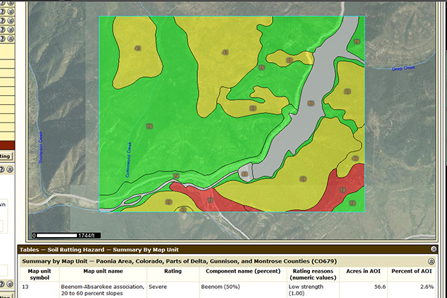
Screenshot of a thematic map from Web Soil Survey
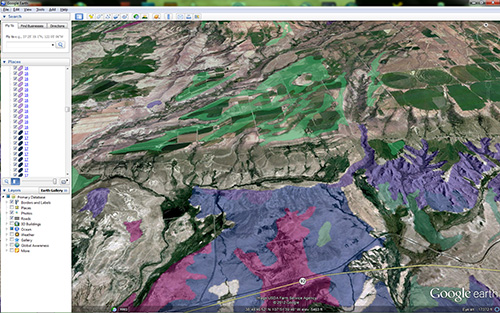
Screen shot of a thematic map overlay in GooglEarth (TM)
This small page is a list of tools and resources that anyone can use to get data and maps of soils in the U.S. Specifically NRCS/NCSS soils maps made by NRCS soil scientists.
Hard copy maps and data reports can be printed and you can save electronic copies (.pdf) files of the same information.
Who needs soil
maps?
- Farmers and Ranchers
- Natural Resource Managers
- Land use Planners
- Land Developers
- Consultants
- Engineers
- Natural Science Researchers
- Farmers and Ranchers
- Natural Resource Managers
- Land use Planners
- Land Developers
- Consultants
- Engineers
- Natural Science Researchers
Web Soil Survey (WSS)- This is typically the "official" source of soil survey information that NRCS field offices use unless otherwise directed in the Field Office Tech Guides (such as HEL lists). This is a robust interactive database and on-line GIS application in which you can get all of the traditonal soil survey data but with much more functionality to address your specific needs. Hard copy maps and reports can be printed or saved from this site as well as GIS data files (shape files) to use in your GIS application.
WSS online help - fairly straight forward help to get you going or solve your problem.
WSS Tutorial - Another good place to go for help. The powerpoint presentation isn't always clear but if you stick to the ordered screenshots it should go pretty well. Personally I would recommend that you first navigate around the site and play with the options that interest you and then go to the tutorial or online help.
Soil Data Mart - This is the original location of official soil survey information. There is no mapping capability but you can still run reports and download GIS and tabular data (Access files). It is likely that this site will soon be phased out in favor of WSS.
Soil Data Viewer - This is a tool built as an extension to ArcMap GIS software by ESRI that allows a user to create soil-based thematic maps. The application can also be run independent of ArcMap, but output is then limited to a tabular report. It is easier to use than ArcMap but it still requires a good working knowledge of the ArcMap software.
SoilWeb - Want to know what soil you're standing on? Download this app for Android and iPhone. The only downside is you have to be within 3G service. It would be nice to have a map too but this is still a pretty neat app for agriculture and natural resource geeks like us.
GIS Software (free)
Not exactly soil maps (but they are good tools to use with soil map files).
MapWindow - Open source GIS software with much of the same functionality as ESRI's ArcGIS (which runs well over $1000 last I checked). I use it frequently at home.
Google Earth (online)
ArcGIS Explorer (online)
Geospatial Data Gateway - A variety of free GIS data including ortho photo imagery.
Online Atlas
Nationalatlas.gov - VERY useful interactive atlas where you can "find yourself" and almost anything else. Topo Quad boundaries, PLSS, Roads, Water bodies, biologic and agricultural data...tons o stuff. Go to the "Map Maker" link in the menu at the top of the page.
I also offer thematic soil map overlay files for use in any version of Google Earth(TM), or ArcGIS Explorer(TM). They are as simple to use as any other Google layer, no GIS experience required (just open the file in the program).
Thematic maps illustrate a specific soil property, or interpretation, in a range of color graphics. I can make themes of most of the properties listed in WSS.
The
thematic maps generated in Web Soil Survey are great (and free) but
they are "static" and
cannot be manipulated or used in other software (GoogleEarth,
ArcGIS Explorer, ArcGIS). This may be possible in the future but it will likely
be a
while.